Stop 3 of 12
Ground-dwelling fauna monitoring
Pitfall traps
Traps used to monitor ground-dwelling amphibians, reptiles, mammals and invertebrates for ecological studies and teaching.
Look forLook for the pitfall trap area, and the transition from dry Eucalyptus-dominated forest toward wetter Melaleuca-dominated forest.
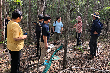
What this is
- QUT staff build pitfall traps at SERF that target ground-dwelling amphibians, reptiles and mammals.
- Buckets are dug flush with the ground and linked by green mesh drift fence that funnels small animals into the buckets. Leaves, twigs, a damp sponge and a float protect trapped animals from predation, heat, cold and water.
- Students camp at SERF, leave traps overnight and check them early in the morning before buckets get too hot. Animals are recorded and released.
Why it matters
- Repeat monitoring lets researchers estimate species occurrence, activity, distribution and microhabitat use over time.
What to notice
- Habitats used by ground-dwelling animals: burrows, grass, hollow logs, standing dead trees and rocks.
- A shift in forest type ahead, from open dry Eucalyptus forest to a wetter, denser Melaleuca-dominated forest as the ground drops away.
Research connection
Long-term pitfall trapping supports ecological studies and teaching, and contributes to the ant biodiversity indicator used in TERN plot monitoring.
Source: QUT Engaging Science Trail, Stop 3
Open in maps
If your preview blocks the map page, copy the link and open it in a new tab.
External maps open the stop location only. Use the in-app trail overview for moving between stops.
Next on the trail
Stop 4: Natural spring and watercourse
Continue downhill toward the natural spring and watercourse crossing.
Orientation assist
The next stop is roughly southwest from here. Use the trail map and site signs or markers where available to stay oriented.
When you arrive, look forLook for the spring-fed watercourse as the trail moves downhill toward the creek and Melaleuca paperbarks.
Follow the numbered trail overview and site signs or markers where available.
Can't find the next stop?
Return to the trail map and check the nearest on-site marker or sign. Stay on marked public paths and do not rely on this prototype for turn-by-turn navigation.
Back to trail mapWas this useful on the ground?
Local prototype feedback. Stored on this device only.