Trail overview
12 stops through SERF
A joint SERF TERN interactive trail through south-east Queensland bushland. Each stop pairs research infrastructure with things to notice on the ground.
Finding your way
Use the static trail map and any on-site markers to follow the 12-stop sequence. This prototype supports orientation and stop recognition, but does not provide turn-by-turn navigation.
The numbered sequence includes the main circular trail and a furthest-point spur to Stops 11 and 12. Stop 10 is the last stop on the circular trail before returning to The Barracks.
Stop pages include an orientation assist line showing the rough direction of the next stop.
Access and orientation
Start from The Barracks / Homestead and follow the numbered trail sequence. The trail includes the main circular route and a furthest-point spur to Stops 11 and 12.
External maps open individual stop pins only. Use the in-app trail overview and site signs or markers where available for movement between stops.
More about access
Twelve numbered stops make up the trail sequence.
The in-app numbered overview is the curated sequence to follow on site.
Other access details are still being confirmed with the facility. Check with SERF before planning a visit.
Site map with numbered stops
Tap a number
Use this numbered overview for the trail sequence. External maps open individual stop pins only.
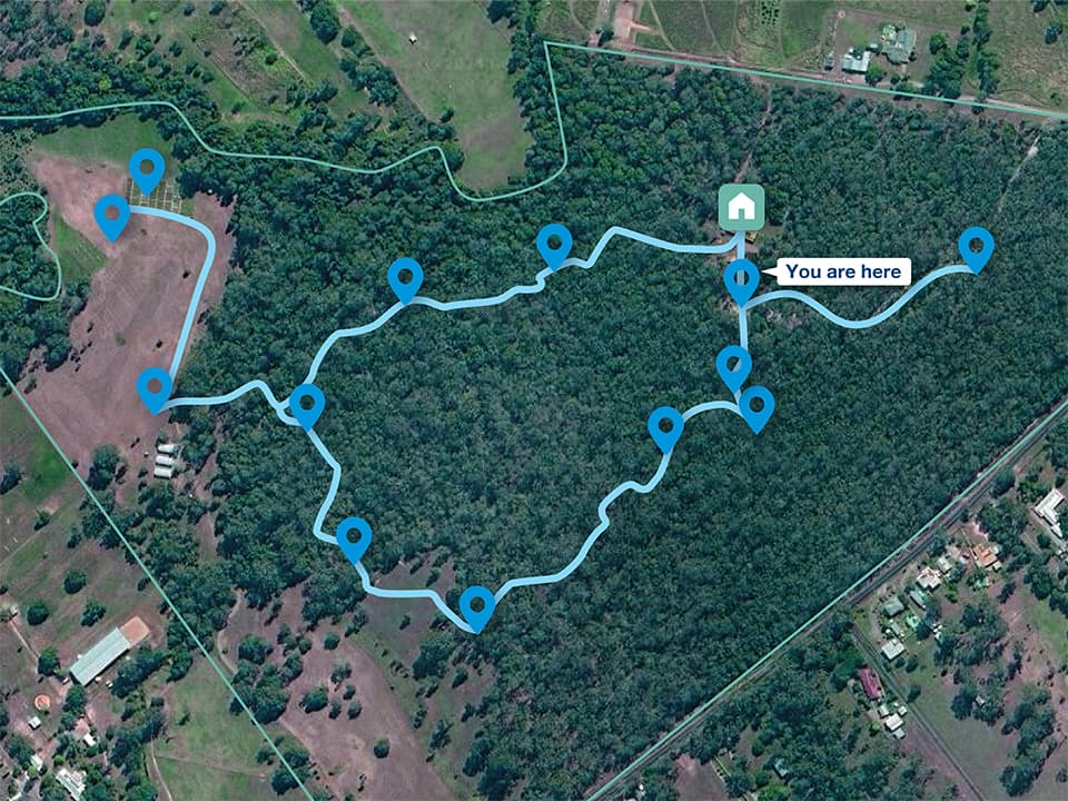
The Barracks is marked on the map as You are here. It is an orientation point, not a numbered stop.
The numbered sequence includes the main circular trail and a furthest-point spur to Stops 11 and 12. Stop 10 is the last stop on the circular trail before returning to The Barracks.
Trail sequence diagram
Trail sequence diagram
Tap a number
A simple diagram of the 12 stops in order. The numbered site map above is the main visual reference.
The numbered sequence includes the main circular trail and a furthest-point spur to Stops 11 and 12. Stop 10 is the last stop on the circular trail before returning to The Barracks.
Approximate overview. Not live navigation.
Furthest-point spur to Stops 11 and 12.
Orientation anchor. Not a numbered stop.
I'm at stop
Manual. No GPS.
Stops
12 entries
Long-term ecosystem monitoring
TERN one-hectare plot
A one-hectare monitoring plot established in 2010 as part of Australia's national ecosystem observation network.
Soil hydrology
Soil moisture probe
Probes measuring volumetric soil moisture in 10cm increments to a depth of 1.2 metres.
Ground-dwelling fauna monitoring
Pitfall traps
Traps used to monitor ground-dwelling amphibians, reptiles, mammals and invertebrates for ecological studies and teaching.
Freshwater habitat
Natural spring and watercourse
A spring-fed watercourse that meanders through SERF and joins Samford Creek on the north-western boundary.
Acoustic ecology and weed control
Acoustic sensor
Solar-powered acoustic recorders that listen to SERF's ecosystems as part of the Australian Acoustic Observatory.
Art, science and education
Opening to cleared pasture
A long-term art and science site on a regenerating forest bank, and the outdoor classroom for QUT's high-school biology program.
Soil science and classification
Soil pit
A teaching pit where students learn to read soil horizons through colour, texture and structure.
Screenhouses and reforestation
Research infrastructure
Open pasture used for insect screenhouse research and an active riparian reforestation project.
Old-growth habitat tree
Blue Gum
A 300 to 400 year old Blue Gum, the magnificent Elder of the Forest at SERF.
Rainforest transition
Riparian zone and pedestrian bridge
A creek crossing where visitors step from dry sclerophyll forest into a gallery rainforest riparian zone.
Greenhouse gas exchange
TERN Flux station
An Eddy Covariance Flux Tower measuring gas exchange between land, vegetation and the atmosphere.
Soil carbon and agriculture
Pasture soil carbon project
Research into how grazing, plant diversity and drought affect soil carbon, water use and productivity.
After stop 12
A short completion layer draws together the bequest that made SERF possible.